Nanbu, Aomori
Nanbu
南部町 | |
|---|---|
 Nanbu Town Hall | |
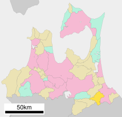
 Location of Nanbu in Aomori Prefecture | |
 | |
| Coordinates: 40°28′1″N 141°22′54″E / 40.46694°N 141.38167°E | |
| Country | Japan |
| Region | Tōhoku |
| Prefecture | Aomori |
| District | Sannohe |
| Area | |
| • Total | 153.12 km2 (59.12 sq mi) |
| Population (March 1, 2023) | |
| • Total | 16,885 |
| • Density | 110/km2 (290/sq mi) |
| Time zone | UTC+9 (Japan Standard Time) |
| Phone number | 0178-84-2111 |
| Address | 23-1 Shimojuku, Sannohe-gun, Nanbu-machi, Aomori-ken 039-0802 |
| Website | Official website |
| Symbols | |
| Bird | Japanese bush-warbler |
| Flower | Peony |
| Tree | Japanese red pine |

Nanbu (南部町, Nanbu-chō) is a town located in Aomori Prefecture, Japan. As of 1 March 2023[update], the town had an estimated population of 16,885 in 7466 households, and a population density of 110 persons per km2 .[1] The total area of the town is 153.12 square kilometres (59.12 sq mi).[2]
Geography
[edit]Nanbu is located in southeastern of Aomori Prefecture, in the eastern part of Sannohe District. The Mabechi River flows from east to west in the center of the town. The terrain is flat along the Mabuchi River, but there are few flatlands and most of the town is hilly. In the southern part of the town, Mt. Nakui has an elevation of 615 meters.
Neighbouring municipalities
[edit]Climate
[edit]The town has a cold maritime climate characterized by cool short summers and long cold winters with heavy snowfall (Köppen climate classification Cfa). The average annual temperature in Nanbu is 10.0 °C. The average annual rainfall is 1198 mm with September as the wettest month. The temperatures are highest on average in August, at around 23.0 °C, and lowest in January, at around -2.1 °C.[3]
Demographics
[edit]Per Japanese census data,[4] the population of Nambu has declined over the past 60 years.
|
| |||||||||||||||||||||||||||||||||||||||
| ||||||||||||||||||||||||||||||||||||||||
History
[edit]When the Nanbu clan relocated from Kai Province to their holdings in Mutsu Province in the early Muromachi period, they established their residence and clan temple in what is now the town of Nanbu.[1] During the Edo period, the area was controlled by Morioka Domain and later by Hachinohe Domain. Hirasaki and Muko villages were created with the establishment of the modern municipalities system on April 1, 1889. These two villages merged on April 20, 1955 to create the village of Nanbu. Nanbu was elevated to town status on February 11, 1959. On January 1, 2006, Nanbu merged with Fukuchi and Nagawa into the new town of Nanbu.
Government
[edit]Nanbu has a mayor-council form of government with a directly elected mayor and a unicameral town council of 16 members. Nanbu is part of Sannohe District which contributes three members to the Aomori Prefectural Assembly. In terms of national politics, the town is part of Aomori 2nd district of the lower house of the Diet of Japan.
Education
[edit]Nanbu has eight public elementary schools and four public middle school operated by the town government and one public high school operated by the Aomori Prefectural Board of Education.
Economy
[edit]The economy of Nanbu is heavily dependent on agriculture, especially horticulture. The main crops are apples, grapes and European pears.
Transportation
[edit]Railway
[edit]![]() Aoimori Railway Company – Aoimori Railway Line
Aoimori Railway Company – Aoimori Railway Line
- Sannohe – Suwanotaira – Kenyoshi – Tomabechi
Highway
[edit]Local attractions
[edit]- Ruins of Shōjujidate Castle, a National Historic Site[5]
- Nakuidake Prefectural Natural Park[6][7]
Noted people from Nanbu
[edit]- Yoshimi Akaishi, voice actor
- Hirotaka Neichi, professional baseball player
- Satoru Sakamoto, musician
- Tsutomu Sakamoto, cyclist, bronze medal winner in 1984 Summer Olympics
References
[edit]- ^ a b "Nanbu town official statistics" (in Japanese). Japan.
- ^ 詳細データ 青森県青森県南部町. 市町村の姿 グラフと統計でみる農林水産業 (in Japanese). Ministry of Agriculture, Forestry and Fisheries. 2016. Retrieved 13 July 2017.
- ^ Nanbu climate data
- ^ Nambu population statistics
- ^ 聖寿寺館跡 しょうじゅじたてあと. Cultural Heritage Online (in Japanese). Agency for Cultural Affairs. Retrieved 6 March 2017.
- ^ 青森県内の自然公園 [Natural Parks in Aomori Prefecture] (in Japanese). Aomori Prefecture. Retrieved 22 August 2012.
- ^ 名久井岳県立自然公園 [Nakuidake Prefectural Natural Park] (in Japanese). Aomori Prefecture. Retrieved 22 August 2012.
External links
[edit]![]() Media related to Nanbu, Aomori at Wikimedia Commons
Media related to Nanbu, Aomori at Wikimedia Commons
- Official Website (in Japanese)


